I have produced a Google Earth kmz file for the erratics I have mentioned so far. Click on the link below and you should be able to download the file. You will need to have Google Earth installed.
http://sdrv.ms/TLx3YW
Any updates to this would be most welcome, and I will post changes here.
Many thanks.
Monday 28 January 2013
Sunday 27 January 2013
Other Erratics around Castlemartin
More Erratics


On St Govan's Head (SR9739 9297) is another erratic, which was probably disturbed when the tank gunnery range was laid out on the headland. It seems to lie in/by an old pop-up target pit. The tape is 1 metre.
.jpg)
The view below is of the same stone, with an old target dugout/bunker in the background. Church Rock, in Broadhaven, can be seen in the distance.

The next example is resting against the south gable of Church House near St Twynnells church, near the postulated site of William Poyer's Longstone (SR94989757)


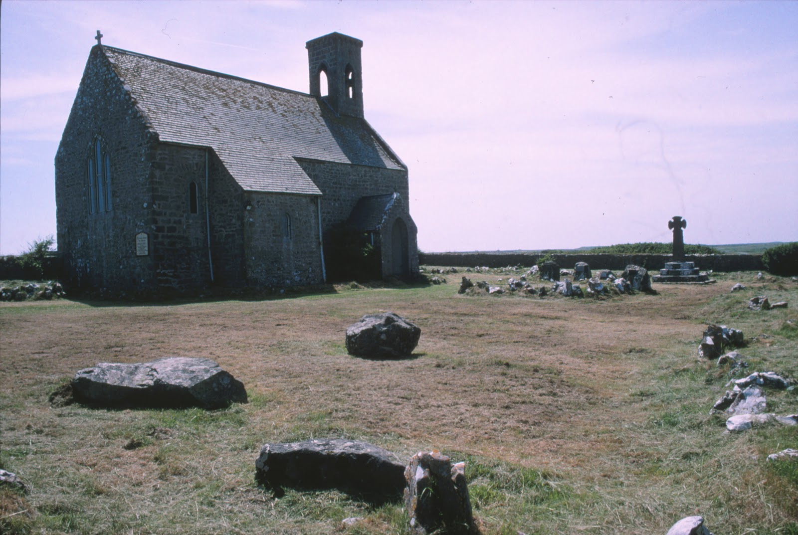
Flimston Chapel churchyard (SR92399558). There is a substantial collection of erratics in this churchyard. Some have been used as headstones for the graves of members of the Lambton Family who died in military service. Others have been left sitting in one corner of the enclosure. All of these stones arrived in the churchyard when the chapel was renovated and re-consecrated in 1903. There are 7 of them. A pamphlet, which describes the features and memorials in the yard, printed at the time of the opening of the chapel in about 1914, gives us these vague details:
No. 1 Boulder, at the head of Lady Victoria Lambton's grave was taken from just opposite Flimston Cottage. A 'brecciated spherultio, albite, trachyte or rhyolite.' Many occur in Pembrokeshire. This one 'seems to fit best with those of Romans'Castle in the character of its spherulites and groundmass.' Most of these appear to have travelled over 30 miles from the N. West separated from their parent rocks by St Brides Bay and Milford Haven, and by a considerable mass of high ground.........
[Flimston Cottage stood at SR927955, about 0.3 km ESE of the chapel and just north of the old clay pits.]
......No. 2 Boulder, from Pwlslaughter, which stands in the opposite North corner. [Bullslaughter, SR942944 - approximately 2.25 km SE]
No. 3 Boulder from Bulliber Farm [About 2.25 km WNW, at SR905968]
No. 3 Boulder from Merrion pond. [ About 2 km NE].
No. 5 Boulder from Lyserry Farm
No. 6 Boulder from Lyserry Farm.
No.7 Boulder from Lyserry Farm.
[Lyserry is about 3.4 km ENE of Flimston chapel, at SR9556967]
Clearly there was some significance in dragging these rocks from their resting places about the area, but quite what the intention was is unclear. It seems likely, as I have mentioned elsewhere, that they were all intended to be memorials or headstones.

Between Mewsford and Bullslaughter Bay (SR94099405). This stone seems similar to some of those at Flimston Chapel, and indeed, the stone of St Govan's Head, mentioned above.


In the background of the picture below can be seen a target operating and observation dugout, of a type built on the range in about 1942.


There are other erratics in the area, but as yet I have not photographed them.
I am hoping to update this posting in the future with a Google Earth file that will plot the locations of the erratics I know about in the Castlemartin area.
Do you know of any others in South Pembrokeshire?
Monday 21 January 2013
More Erratics and a Hidden Building
 In the last post I mention a cup like mark on the upper surface of the stone in Loveston farmyard. I know little about what to look for in "Cup and Ring" markings, but I have ordered a book today to try and learn more:
British Prehistoric Rock Art - ISBN: 9780752425146, Beckensall, Stan
I suspect the mark I have seen is nothing but an "accidental chip off the old block", but it is an excuse to look into the topic in more depth!
Having spent a good 45 minutes examining the Loveston stone, I then had a look at some old ruins that the farmer, Mr Morris, had pointed out to me, incorporated into a cow shed on the western edge of the farmyard. There were two bullocks in the shed, so I could not get inside, but from the outside a huge arched fireplace was visible in the north end of the shed, deep in the shadows.
Walking around the outside of the building, it was clear that the stonework of the wall was good quality, late medieval(?) masonry. The quoins were large, squared-off, limestone blocks, and the building had little foundation - sitting on an outcrop of same carboniferous limestone. The chimney stack attached to the north gable of the fragmentary remains was of classic massive South Pembrokeshire proportions. The gable was cloaked in thick ivy, so much of the detail was difficult to see. First thoughts were that it might be the remains of a small tower house, like that at Carswell near Tenby. (See http://www.pemcoastphotos.com/_photo_7481978.html for other fantastic photographs like this.)
 |
| Carswell, Nr Tenby. The ivy clad building fragment bears a strong resemblance to the gable and stack of this medievel building. |
Looking at old maps of Loveston, the size of the old building is visible in the c1866 Ordnance Survey map of the area (marked A).

By 1908 this same building had been extended.

The large chimney on the north gable of the structure can be clearly seen in both maps, as it can in the 1971 map below.

The earliest map above shows the possible original size of this building, sited on the side of what was originally the lane from St Twynnells Church to the coast. At the time the now ruined building would have been built, the new east-west road running just north of the farm did not exist. This road was built c.1820 to link Stackpole Court with Brownslade.
The picture below shows the remains (exciting - isn't it!!!!!) viewed from the west in January 2013. Apologies for the vivid green grass and the sarcasm.

The length of wall visible shows no very obvious breaks in build, but the cattle troughs obscure some detail. The northern end of the wall seems to have more "batter". The picture below shows the quoin on the NW corner of the building. In front of the wall is another possible erratic boulder, seemingly placed here quite recently.

I'll come back and look at this building soon and explain how it might help work out the history of the Loveston Erratic and how it came to be in the yard. Something has just occurred to me..........
Thursday 17 January 2013
The Loveston Erratic Revisited
A closer view of the Loveston stone.
I have been back to look at the Loveston Erratic, in the farmyard in St. Twynnells, Pembrokeshire. See my previous posts and the discussion at Brian John's blog, here:
http://brian-mountainman.blogspot.co.uk/2012/12/the-loveston-erratic.html
I was also able to have a good discussion about the stone with the farmer, Mr Morris. He told me that the stone had always been in the yard, as far as he could recall. about forty years ago people came "down from Cardiff" and took photographs of the stone and tried to cut a slice off it - hence the groove on the upper surface of the stone. The northern end of the stone, hidden from view in the picture I posted before, has a very clean, smooth, seemingly sawn, face. See the photographs below.
The photograph below shows (rather badly) a cup like mark on the stone. Has the appearance of having been scooped out.
According to Mr Morris, over the years various people have come to the visit the stone and comment on it.Some have said that it was a stone left behind whilst transporting the "Bluestones" to stonehenge. By man or by ice?
The stone was listed, but is now no longer so, but there is no intention to remove it. It is Mr Morris's belief that it gives the name to the farm - Loveston(e).
Comments and thoughts very welcome!
http://brian-mountainman.blogspot.co.uk/2012/12/the-loveston-erratic.html
I was also able to have a good discussion about the stone with the farmer, Mr Morris. He told me that the stone had always been in the yard, as far as he could recall. about forty years ago people came "down from Cardiff" and took photographs of the stone and tried to cut a slice off it - hence the groove on the upper surface of the stone. The northern end of the stone, hidden from view in the picture I posted before, has a very clean, smooth, seemingly sawn, face. See the photographs below.
 |
| The Erratic in the farmyard at Loveston, viewed form the west in January 2013. |
 |
| View of stone from the east. The book is 32 cm long. |
 |
| View from north-east . The book is 32 cm x 24 cm. |
 |
| View from north. Note flat "sawn" end. Attempt at cutting the stone can be seen running away from the camera. |
 |
| View from north-west. |
 |
| View from WNW appx. |
 |
| View from WSW appx. |
 |
| View from south-west appx. |
 |
| View from south. |
 |
| View from SSE appx. |
 |
| View from south-east. |
 |
| Saw cut in top of stone. |
 |
| Saw cut in top of stone. Edge of book is 24 cm parallel to cut. |
 |
| Another view of saw cut. |
 |
| Cup like mark on upper surface of stone. About 1cm deep. |
 |
| Looking down on north plane face of stone. |
The stone was listed, but is now no longer so, but there is no intention to remove it. It is Mr Morris's belief that it gives the name to the farm - Loveston(e).
Comments and thoughts very welcome!
Subscribe to:
Posts (Atom)